Oregon
Hinterlands
White River Falls
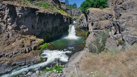
White River Falls
What an experience we had on this lovely, sunny, and very hot day. Our destination was Bend, Oregon but we decided to take the inland route via the Dalles and highway 197. After driving along, the magnificent Columbia River we turned south at the Dalles and then continued until we reached highway 216 where we turned eastward. Soon we arrived at the stupendous White River Falls. We hiked down into the valley and joined the river. We ate lunch at a derelict power plant and then continued to follow the river until we ran out of the accessible trail. Even though it was blisteringly hot, and I injured myself scaling the scree covered trail we really enjoyed this hike.
Here’s what the AI-Oracle has to say about White River Falls’ history:
White River Falls State Park has an interesting history. The area was once known as Tygh Valley State Wayside, and Pacific Power and Light Company gave the state 255.13 acres in 1969. In 1970, the state received a patent on 40 acres formerly held by the Bureau of Land Management. In 1978, a land exchange with a private property owner completed the park.
Pacific Power and Light Company acquired the White River Falls area for hydroelectric generation in 1910 and produced electricity there until 1963.
Dee Wright Observatory
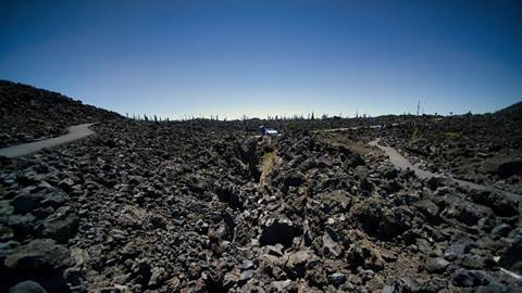
McKenzie Highway
After our stay in lovely Bend, we drove the (often closed) McKenzie Highway home.
Oregon and Washington States are both bisected by the Cascade Mountain Range. This range of massive volcanic mountains is littered with a highly pyroclastic history. This fiery history is no more apparent than at the Dee Wright Observatory, which is where the McKenzie Highway leads you to as you climb through the majestic Cascades.
We roamed about a trail hacked out of the lava and climbed up to the Dee Wright Observatory where we took in the amazing views of volcanic mountain peaks, and miles of black lava.
Here’s what the AI-Oracle has to say about Dee Wright Observatory:
The Dee Wright Observatory is constructed on the lava flow which erupted from Yapoah Cone 2,600 to 2,900 years ago; this flow overlaps an earlier flow from the Little Belknap Crater. The basaltic lava found in the area is called A A lava (pronounced “Ah Ah”); and is characterized by its rough and jagged surface.